Excerpts from: “Striking Eight Bells: A Vietnam Memoir.
U.S. Navy Atlantic Fleet destroyers make the long passage to Vietnam during late 1972.
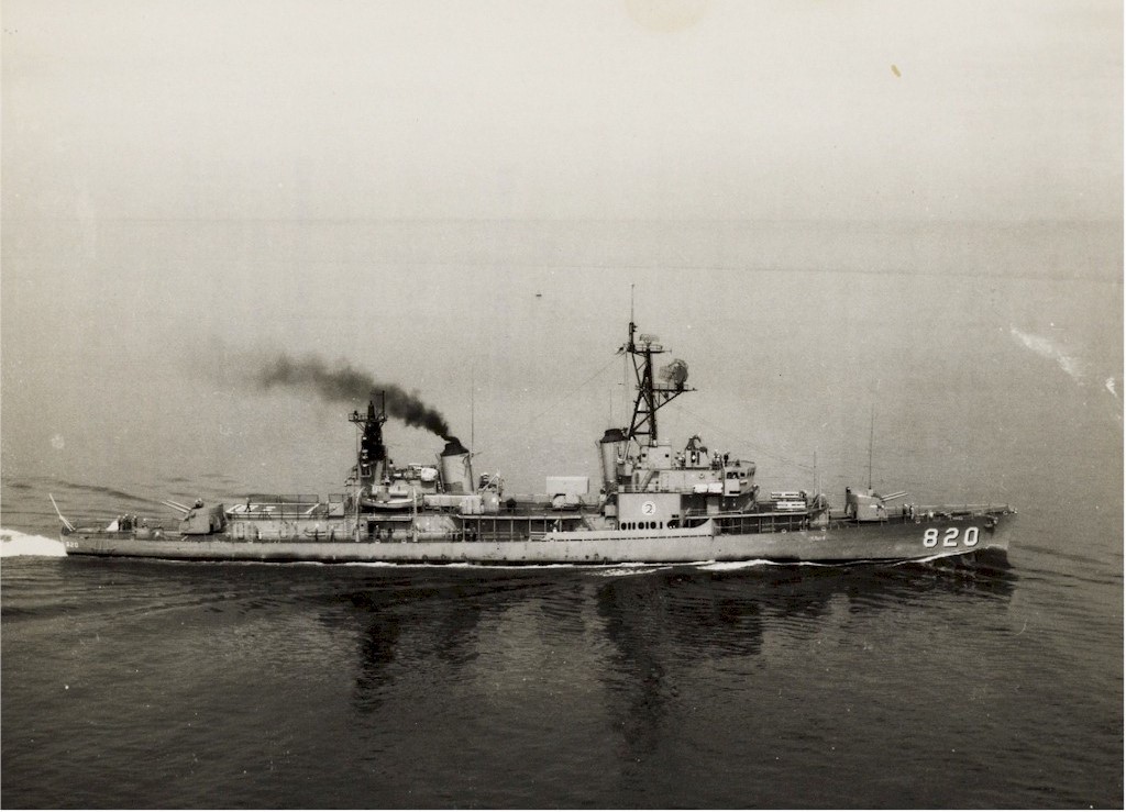
On November 15, after refueling the ship in Apra Harbor, Guam, USS Rich (DD 820) got underway at 1400 that afternoon and steamed back out to sea. Once the ship was in open water, a westerly course was set to the San Bernardino Strait in the Philippine Islands. The passage plan distance was 1,655 nautical miles from Guam to Subic Bay on Luzon via the San Bernardino Strait.
The passage would take a little less than three days of steaming through the Western Pacific Ocean waters. The planned overall SOA was 23 knots versus the normal transit speed of 16 knots. The next day, November 16, we had caught up to Typhoon #29, Typhoon Ruby. By today’s standards, Ruby would be a Category 3 Typhoon on the Saffir-Simpson Scale. The Saffir-Simpson Scale provides some indication of the potential damage and flooding a hurricane will cause at landfall, so it’s meaningless to a mariner at sea. The winds in this typhoon were forecast to reach up to 110 knots (126 mph).
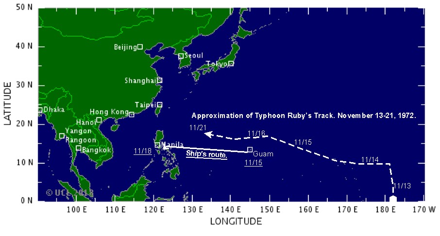
The ship began to experience ever-increasing waves, and the wind had veered around to the west and southwest. Each hour, both the wave size and wind speed continued to incrementally increase. By the afternoon, the ship was in the midst of a powerful Pacific typhoon. The good news was that we were fairly certain the ship’s position was on the left side of the typhoon’s track, also called the navigable semicircle. We also knew we were in a position ahead of the storm’s track and possibly could just outrun the storm.
Throughout the day the ship experienced ever increasing heavy rolling and pitching, and we could see as the waves broke over the bow that the forward gun, mount 51, was submerging with each breaking wave. The winds and seas had become dangerous. We began to record true wind gusts in excess of 90 knots (104 mph), but the waves were approaching 40 feet in height, slamming in one after the other just off the port bow. Except for wind gusts, the sustained true wind speed consistently ranged between about 65 to 75 knots (74 to 86 mph).
Finally, several hours after being relieved of the Quartermaster of the Watch (QMOW) at 1600, the severity and forcefulness of the ship’s rolling and pitching seemed somewhat reduced as compared to what it had been earlier in the day. I hadn’t eaten since breakfast; many in the crew had also not eaten that day, as it had just been too rough. Those who had them got by eating saltine crackers. I put in a wake-up call on the bridge for 2300 and hit my rack to try to get some sleep before the mid-watch.
When the messenger of the watch woke me at 2300, I hopped up and out of my rack. As I was dressing, I realized that the ship’s rolling and pitching had lessened even more. I made my way to the galley to see what was being served for mid-rats (midnight rations). Damn, another score of a fried egg and bologna sandwich with coffee and bug juice (a type of Kool-Aid) for my mid-rats meal. Now, I would be going on watch with something in my stomach.
On arriving on the bridge, it appeared that the weather conditions had improved considerably from seven hours earlier. The QM and the OOD seemed sure that Typhoon Ruby was well astern of us now and we were continuing to open the distance. It appeared the immediate danger from the typhoon was over. I chalked it up as my first experience with a tropical storm at sea. Over the next 12 hours of steaming through the Philippine Sea, the weather conditions continued to improve; by morning, the western skies were fairly clear and the sea waves had reduced to a more than manageable height of 16 feet or less.
The next afternoon, the ship was approaching the San Bernardino Strait. The San Bernardino Strait is a strait in the Philippines connecting the Philippine Sea with the Samar Sea. The strait separates the Bicol Peninsula of Luzon Island to the north from the island of Samar to the south. As the ship approached the northern entrance of the strait, we sighted Mount Bulusan to our north. Mount Bulusan is one of the active volcanoes in the Philippines.
The passage plan distance from the entrance of the San Bernardino Strait to Subic Bay on the southwest coast of Luzon was about 240 nautical miles. Most of the transit would take place at night through the northern islands’ passages to Subic Bay. After getting off watch, the Navigation Detail was set for the rest of the passage. As we came closer to northern point of Samar Island and the San Bernardino Islands, the topography of the islands ranged from high bluffs and cliffs to areas of dense vegetation and jungle.
One of the junior officers made the comment that many of the islands are so remote and isolated that it was possible there still could be Japanese soldiers from World War II in the Philippine Island jungles. It turned out his comment was not that far off the mark. Less than two years later, during the spring of 1974, Second Lieutenant Hiroo Onoda of the Japanese army made world headlines when he emerged from the jungle on Lubang Island after 30 years. Lieutenant Onoda was convinced that World War II was still being fought. In 1999, his book was published titled No Surrender: My Thirty-Year War.
The QM gang stayed on the navigation detail throughout the night as the ship navigated its way through the Ticao Passage, then between Ticao and Burias Islands into the Sibuyan Sea. The navigation detail is different from the sea and anchor detail. When the navigation detail was set, the QMs assisted the navigator in more frequently fixing the vessel’s position. Here the method of navigation is all piloting navigation, where the vessel’s movement is directed by frequently determining the ship’s position using visual compass bearing and/or radar bearings and ranges to fixed and charted aids or objects. Soundings (actual depths of the water under the ship’s keel compared to the charted depths) to help confirmed the actual position are also used. The westward passage took the ship through the Sibuyan Sea, then through the Verde Island Passage. From the Verde Island Passage, the ship steamed northwest along the coast of Luzon to Subic Bay.

The ship docked the next morning, November 18, at the Subic Bay Naval Station in Subic Bay Harbor at 0710. The transit from Norfolk to Subic Bay had taken one month and one day, 32 days total. Of the 32-day transit, almost 29 of those days had been at sea. The ship would remain in Subic Bay for six days while making the necessary preparations and alterations to enter the combat zone of Vietnam. Our ship was docked at Pier 16-17, Rivera Point Ship Repair Facility.

The ship was moored with our starboard side to outboard of USS Hepburn (DE 1055), and USS Parks (DD 884) was moored outboard on our port side. We were scheduled to depart Subic Bay early in the morning on Friday, November 24. The passage plan distance from Subic Bay to Military Region I located in northern South Vietnam was about 805 nautical miles. The passage to Vietnam would take close to 37 hours at the planned passage speed of 22 knots…to read “Striking Eight Bells,” use one of these links to booksellers: Amazon.com: Books, Barnes and Noble Booksellers, BAM –Books A Million and Smashword.com eBooks.

